
A wall of smoke from wildfires burning hundreds of miles away in Minnesota and Ontario has settled over the Great Lakes and is now sliding south into central Indiana, prompting a run of state air quality alerts this week and turning skies over Clinton, Boone and Carroll counties a familiar summer haze-gray.
Here’s what’s driving it, how long it’s expected to stick around, and what it means for local air, health and travel.
Where the Smoke is Coming From
The haze tracing across the Midwest originates from two fire zones roughly 500 to 700 miles north of Indiana. In northern Minnesota, the Thumb Fire and the Bear Trap Fire have burned through roughly 14,500 and 13,500 acres, respectively, after a lightning-heavy thunderstorm complex swept the region on July 6th.

Those fires prompted evacuations and closures of wilderness areas in the Superior National Forest, where fire officials have warned of extreme, wind-driven fire behavior (U.S. Forest Service).
Across the border in Canada, roughly a dozen large, out-of-control wildfires are burning in western Ontario, with the largest — in Wabakimi Provincial Park, about 135 miles north of Lake Superior — topping 130,000 acres. Smoke from both fire zones has been pulled into the lower atmosphere and pushed south and east by the same weather pattern parking a heat dome over the eastern half of the country — plentiful smoke, but little wind to clear it out.
The smoke has already produced dramatic conditions to our north: the Mackinac Bridge in Michigan was completely obscured by smoke on Wednesday, the Twin Cities saw hazardous particulate readings as high as 617 on the air quality index, and in Toronto, air quality was reported to be roughly five times worse Thursday than the day before, with Thunder Bay’s index exceeding 1,587 — prompting Toronto to cancel outdoor FIFA World Cup watch parties and shutter public wading pools.
How long will it last?
Not a quick clear-out, but also not expected to be as severe here as the historic 2023 Canadian wildfire smoke event that turned New York City’s skies orange and pushed its air quality index to a record 465 (Washington Post).
Forecasters say:
• Dry weather is expected to continue fueling the fires through Thursday, with scattered rain and thunderstorms possible near the fire zones on Friday, which could help slow fire growth.
• Environment Canada meteorologists say conditions may begin improving in the U.S. by Friday, July 17.
• The Washington Post’s forecast team notes a brief shift in wind direction on Saturday could blow a good deal of the lingering smoke out of the region — though wildfire season in Ontario runs through October, meaning this likely won’t be the last smoke event of the summer.
What it means for Clinton, Boone and Carroll counties
The Indiana Department of Environmental Management (IDEM) has been issuing Air Quality Action Days on a rolling basis all week as the smoke plume has crept south, and our three counties have been caught in the swing of it.
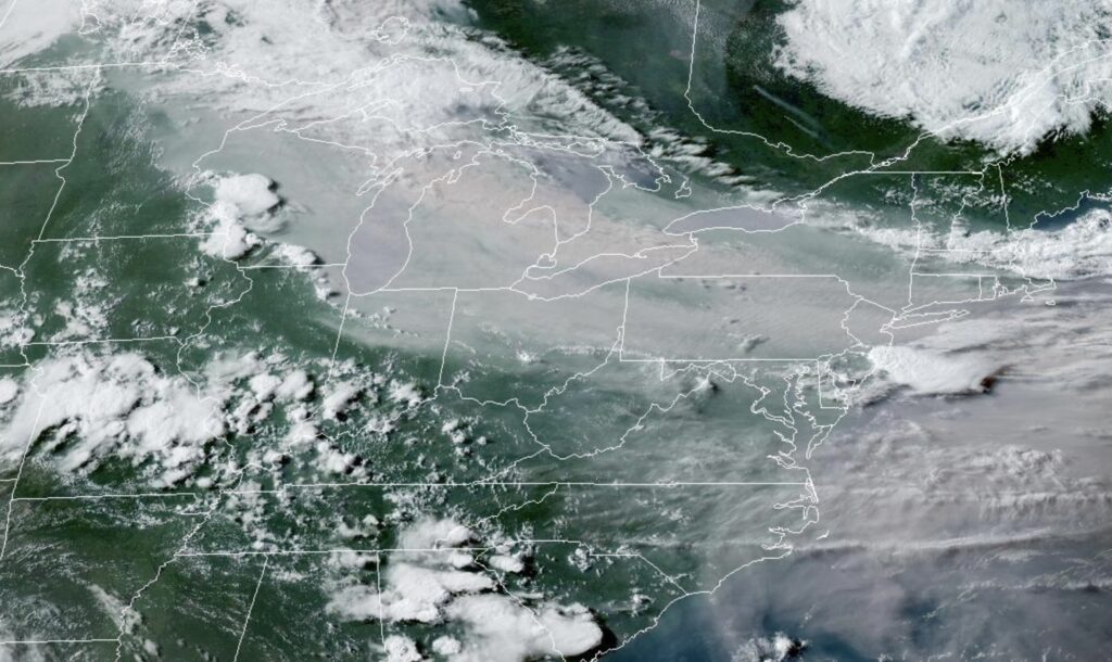
Clinton (Frankfort), Boone (Lebanon) and Carroll (Delphi) counties fall under IDEM’s “Central/East Central” and “Western/West Central” Indiana air quality regions, alongside Indianapolis, Lafayette, Kokomo and Crawfordsville. On Wednesday, July 15, the National Weather Service issued an air quality alert explicitly naming Carroll, Clinton and Boone counties, along with dozens of others, warning that ozone levels would reach the Unhealthy for Sensitive Groups range as wildfire smoke combined with light winds and stagnant, high-pressure conditions.
Thursday’s worst readings — IDEM forecast fine particulate matter (PM2.5) in the “Very Unhealthy” purple range — have been concentrated farther north, in Northwest, North Central and Northeast Indiana (South Bend, Fort Wayne, Elkhart and the surrounding areas), a reminder that the thickest smoke layer is still working its way toward us. As of Thursday afternoon, Indianapolis’s own air quality was still rated “Good,” with PM2.5 readings around 7 micrograms per cubic meter — well below the 35 µg/m³ threshold that triggers an action day.
That’s expected to change. IDEM’s updated forecast calls for an Air Quality Action Day on Friday, July 17, for PM2.5 in the “Unhealthy for Sensitive Groups” (orange) range across both the Central/East Central region (Frankfort, Indianapolis, Lebanon, Kokomo) and the Western/West Central region (Delphi, Lafayette, Crawfordsville) — meaning Clinton, Boone and Carroll counties should plan for hazier skies, and more noticeable particulate pollution, heading into the weekend.
On Action Days, IDEM and local health officials recommend that children, older adults and anyone with asthma, COPD or heart disease limit prolonged outdoor exertion, and suggest keeping windows closed overnight, running air conditioning with a MERV-13 or higher filter, and postponing yard work or lawn mowing until evening (IDEM). For farm families and anyone with outdoor jobs across our largely agricultural counties, that means watching the forecast closely and shifting strenuous outdoor work to cooler, clearer parts of the day when possible.
Residents can track live conditions and sign up for free alerts at SmogWatch.IN.gov or the EPA’s AirNow Fire and Smoke Map.
One silver lining worth a look outside: smoke particles scatter sunlight in ways that often produce especially vivid, deep-orange sunrises and sunsets — a striking, if slightly eerie, photo opportunity for anyone driving the back roads of Clinton, Boone or Carroll counties this week.
Air travel out of Indianapolis and Lafayette
Nationally, wildfire smoke is a bigger air-travel headache than most travelers realize. The FAA has said thick smoke is actually more likely than rain or fog to cause delays, because the tiny solid particles in smoke — unlike water droplets — linger in the atmosphere and interfere with the visibility pilots and navigation systems depend on, forcing controllers to space aircraft farther apart and slow arrival and departure rates.
This week that’s meant ground delay programs and reduced arrival rates at East Coast hubs including Philadelphia, LaGuardia, JFK, Newark and the Washington, D.C.-area airports, as smoke settled over the Northeast (FAA Air Traffic Control System Command Center advisory).
The good news for local travelers: as of Thursday evening, both Indianapolis International Airport (IND) and Lafayette’s Purdue University Airport (KLAF) were reporting normal operations. IND’s FAA status showed only routine gate-hold and airborne delays of 15 minutes or less, with no ground stops or smoke-related restrictions in effect, and the FAA’s national airspace dashboard listed no active smoke or haze events for Indianapolis or the broader Chicago corridor.
At KLAF, Thursday evening’s weather observation showed 10 miles of visibility under clear skies, with no haze or smoke noted.
That could shift along with the smoke itself. Because major airlines route aircraft through multiple hubs, a smoke-related delay in Philadelphia or Newark can ripple downstream to flights connecting through Indianapolis even on a clear local day. Commercial travelers flying out of IND this weekend should check their airline’s flight status before heading to the terminal.
General aviation pilots — including the many private fliers based at airports across Clinton, Boone and Carroll counties — should pay close attention to visibility trends over the next few days rather than airline delay boards. Smoke tends to settle closest to the ground overnight and during the early morning hours when a temperature inversion can trap it near the surface, sometimes dropping visibility well below what a hazy afternoon sky might suggest.
The bottom line for our readers
• The smoke is coming from wildfires burning in northern Minnesota and western Ontario, roughly 500-700 miles to our north, not from any local or regional source.
• Conditions are expected to be worst in Indiana on Thursday and Friday, with a chance of real improvement by Saturday as winds shift — though occasional smoke episodes could recur through the fall as Canada’s fire season continues into October.
• Clinton, Boone and Carroll counties dodged the very worst of this week’s air quality but are forecast to see Unhealthy-for-Sensitive-Groups conditions Friday; sensitive residents should limit outdoor exertion and watch SmogWatch.IN.gov.
• Airline and general aviation traffic at IND and Lafayette’s KLAF have not been directly disrupted so far, though travelers should watch for ripple-effect delays tied to smoke-choked hubs out East, and pilots should double-check visibility before flying.